¿Cómo se repone el agua subterránea?

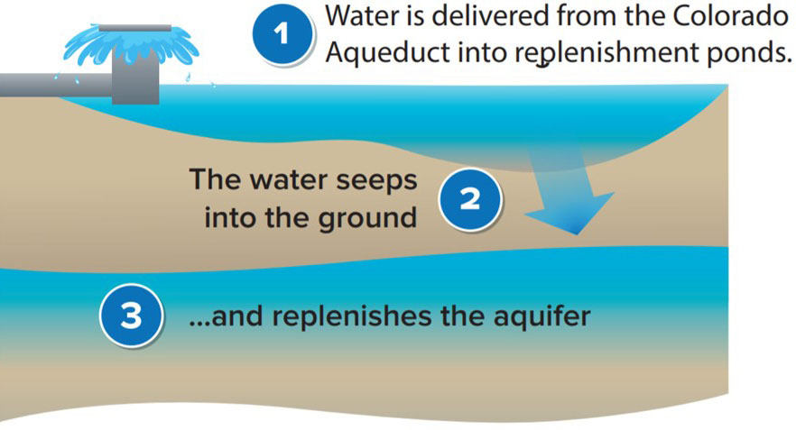
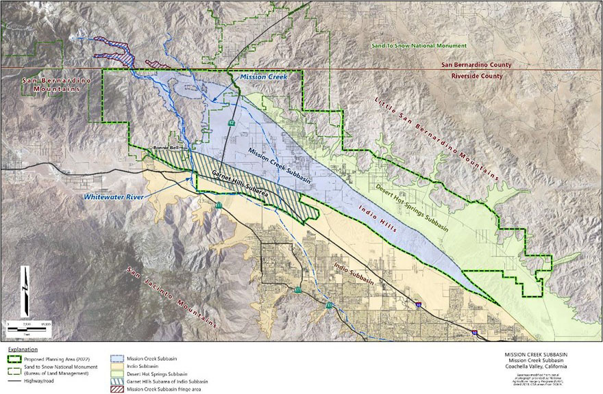
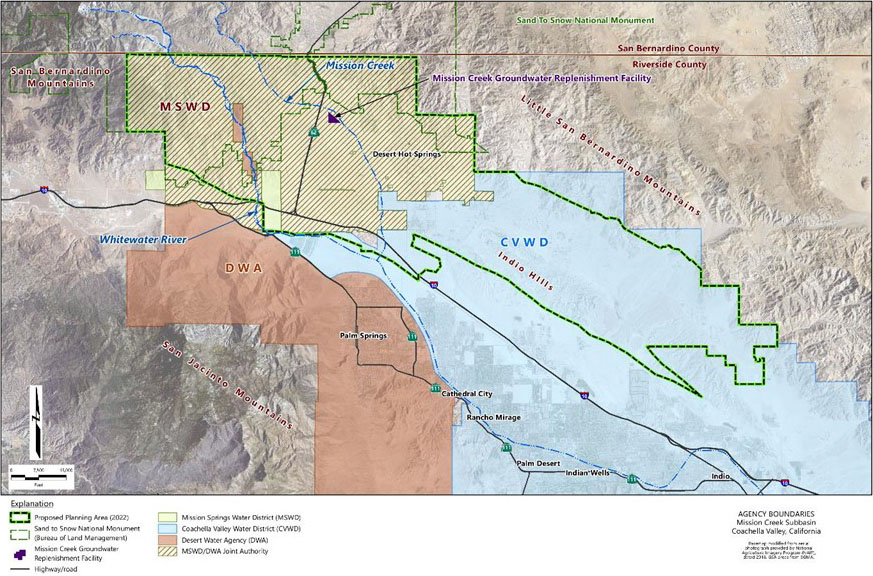
Las cuencas de agua subterránea pueden reponerse de forma natural y artificial cuando se permite que el agua en la superficie se filtre al suelo. La Subcuenca Mission Creek se repone naturalmente con el desagüe de Mission Creek y con poco de flujo subsuperficial que también ocurre en la Subcuenca Desert Hot Springs al norte. Agencias del servicio del agua en la Subcuenca Mission Creek también reponen el agua subterránea de forma artificial con agua importada que se bombea a los que se les conoce como “estanques de recarga” donde se puede filtrar al suelo.

How it Works
Figure 5b: How it Works

¿Qué es la Subcuenca Mission Creek?

Dentro de la región del Valle de Coachella, la Subcuenca Mission Creek está limitada por tres fallas asociadas con el sistema de la falla de San Andrés. Estas fallas separan la Subcuenca Mission Creek de las adyacentes subcuencas de Desert Hot Springs y de Indio, también la subárea Garnet Hill de la Subcuenca de Indio. El borde de las fallas delimita el sudeste de la Subcuenca Mission Creek. Cordilleras limitan el área de la subcuenca completamente por un lado y parcialmente por un segundo lado, lo que conduce a el reabastecimiento de agua subterránea por la escorrentía del agua de las cordilleras.

¿Qué es la Subcuenca Mission Creek?

La Subcuenca Mission Creek es parte de la Cuenca de Agua Subterránea del Valle de Coachella, la cual está designada como la Cuenca № 7-021.02 en el Boletín 118 del Departamento de recursos Hídricos de California (por Department of Water Resources, DWR) (DWR, 2016). Vea el mapa a continuación. La Subcuenca Mission Creek está rodeada por las montañas del Pequeño San Bernardino al este, las montañas de San Jacinto y San Bernardino al oeste, las de Indio Hills al sudeste, y la Subcuenca de Indio al sur. El mapa a continuación también muestra las colindantes subcuencas de agua subterránea.

Mission Creek Subbasin
Figure 7: Mission Creek Subbasin Regional Map

If GSAs are locally controlled, what is the State’s role in this effort?

DWR is the State agency responsible for oversight of the GSAs and GSPs (or Alternative Plas). DWR has a list of regulations, objectives and actions formulated to assist local agencies and GSAs with the preparation and implementation of GSPs and Alternative Plans. Under law, all regulations adopted by DWR only become effective upon approval by the California Water Commission. The State Water Resources Control Board (SWRCB) acts as the enforcement agency that reviews water use data and has the authority to directly manage basins as a result of failure by locals to comply with SGMA requirements (i.e. create a GSA, adopt and implement a GSP or Alternative Plan).

What is the governance structure for the GSA?

The two GSA agencies, Coachella Valley Water District (CVWD) and Desert Water Agency (DWA), as well as Mission Springs Water District are working together under the Settlement Agreement that was signed in 2004. While CVWD and DWA are each exclusive GSAs, they continue to work collaboratively with Mission Springs Water District to oversee and manage the Mission Creek Subbasin.

What authorities will GSAs have?

Under SGMA, GSAs are empowered to utilize a number of new management tools to achieve groundwater sustainability, such as:

  • Adopt rules, regulations, ordinances, and resolutions to implement the Act,
  • Monitor compliance and enforcement,
  • Require registration of groundwater extraction facilities (wells),
  • Require appropriate measurement devices and reporting of extractions,
  • Investigate, appropriate, and acquire surface water rights and groundwater rights,
  • Acquire or augment local water supplies to enhance the sustainability of the groundwater basin,
  • Propose and collect fees, and
  • Impose limits on groundwater extraction.

The GSA may use a number of management tools to achieve sustainability goals. The specific tools and methods the GSA will use to achieve sustainability will be determined in discussion with stakeholders and identified in the GSP or Alternative Plan.

Who is the GSA for the Mission Creek Subbasin?

The first requirement of SGMA was to form a GSA by June 2017. The Coachella Valley Water District (CVWD) and Desert Water Agency (DWA) each submitted application materials to become a GSA for different portions of the Subbasin that overlap their service area. Since establishing as exclusive GSAs, the two water agencies have worked together with the Mission Springs Water District (MSWD) as the Mission Creek Subbasin Management Committee to implement SGMA requirements. See map below for more information on the service area of each agency within the Subbasin.

Agency Boundaries
Agency Service Areas

What is a Groundwater Sustainability Agency (GSA)?

A Groundwater Sustainability Agency (GSA) is one or more local governmental agencies that implement the provisions of SGMA. A local agency is defined as one that has water supply, water management or land management authority. The primary purpose of a GSA under SGMA is to develop and implement a Groundwater Sustainability Plan (GSP) or Alternative Plan to achieve long-term groundwater sustainability.

How will the GSP affect local cities and the county?

SGMA strongly encourages closer planning coordination between water supply and land use agencies to ensure water supply planning accurately forecasts and secures water supplies for future land use changes, and that land use planning considers the effects of projected growth on water resource management. Local agencies are required to acknowledge GSPs or Alternative Plans when a legislative body is adopting or substantially amending its General Plan. General Plans must accurately reflect the information in the GSP or Alternative Plan with regards to available water supplies. In addition, a city or county must now refer the proposed adoption or substantial amendment of a General Plan to any affected GSA(s). In response, the GSA(s) must provide the land use agency with the current version of its GSP or Alternative Plan and any information that is relevant to determining the adequacy of existing and planned future water supplies to meet existing and planned future demands.